Astrotron
I designed Astrotron to assist me in determining if it is worth
trekking to a dark-sky observing point for auroral events and
astro-photography and/or telescopic observation.
This information is specifically calculated for my
observation location, which is in northeast Montana.
If you are significantly distant (more than
50 miles) from where I live, the information displayed by Astrotron
will be incorrect for you. The further away you are, the more inaccurate
it becomes.
I wrote this application for my own benefit (you can see some of my
auroral photography
here
and my astrophotography
here)
but I would be nothing less than delighted if someone else in the local
area was able to take advantage of my work and thereby enjoy some
viewing or photography. I'd love to hear from you if that is the case,
please write to me using the email address [fyngyrz (at) gmail (dot)
com]. I will always answer such an email.
Astrotron is coded in Python, a modern scripting language I very
much enjoy working with. It uses two nonstock libraries, the PIL
library (Python Imaging Library) and the ephem library. I use
PIL to help generate the graphs and meters; and ephem to calculate the
positions of the planets and related astronomical information. I have
split the work so that the ephem-driven portion runs on my Mac, and the
PIL and HTML portions run on my web server, which is a Linux machine.
All work-intensive portions of Astrotron are driven by *nix crontab
launches; loading (and re-loading) the Astrotron page does not cause any
data to be re-calculated; that happens every five minutes whether anyone
is looking at the page or not. The Astrotron page itself will re-load
every five minutes if you simply leave it open in a web browser, thus
always showing you recent information. If you want the most
recent information, load the page at one minute after any five-minute
point on the clock (for instance, at 8:16:00 AM. From there it will
reload by itself at 8:21, 8:26 and so on.) The page itself is not
"heavy" in terms of bytes, and the server can handle a very
large number of requests without a problem.
Availability
As mentioned above, Astrotron runs on my own server, which
disconnects from the Internet every evening from 4:00 AM to 4:30 AM
local time in order to back itself up without external demands being
made on its processing power. So during that 1/2 hour, Astrotron is
unavailable. Keep this in mind and see to it that on evenings where you
might like to use it, you check in with it before it shuts down at 4:00
AM, or be prepared to wait until 4:30 AM.
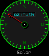
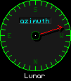
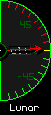
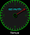
Azimuth and elevation
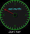 These two dial types are used to locate a celestial
body. Azimuth dials tell you which direction to look; north, south, east
or west. Elevation dials tell you how high up from the horizon to look:
Zero is the horizon, and 90° is straight up. These are marked
"alt" which is short for "altitude." Both dial types
are calibrated in degrees. All you have to know is how the compass
directions relate to where you are observing, and these two dials allow
you to locate something in just moments.
These two dial types are used to locate a celestial
body. Azimuth dials tell you which direction to look; north, south, east
or west. Elevation dials tell you how high up from the horizon to look:
Zero is the horizon, and 90° is straight up. These are marked
"alt" which is short for "altitude." Both dial types
are calibrated in degrees. All you have to know is how the compass
directions relate to where you are observing, and these two dials allow
you to locate something in just moments.
The Sun
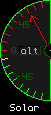


 The first factor to be considered is the sun's elevation.
"Astronomical Darkness" is the period when the sun is 18°
or more below the local horizon, which is the time before, or after,
astronomical twilight. At this point, the sun's illumination
is sufficiently shielded by the body of the earth itself to no longer be
a factor in observing or photography. Basically, if the sun is above
18°, the quality of your observations will be reduced.
The digital altitude readout includes an arrow to indicate if the sun is
rising or setting.
The first factor to be considered is the sun's elevation.
"Astronomical Darkness" is the period when the sun is 18°
or more below the local horizon, which is the time before, or after,
astronomical twilight. At this point, the sun's illumination
is sufficiently shielded by the body of the earth itself to no longer be
a factor in observing or photography. Basically, if the sun is above
18°, the quality of your observations will be reduced.
The digital altitude readout includes an arrow to indicate if the sun is
rising or setting.
The Moon


 With the exception of photographing or observing the moon itself, the
presence of the moon if it is even more than slightly illuminated serves
as a negative factor; the moon's reflected light, as diffused throughout
the earth's atmosphere, will make it very difficult to observe faint
auroras, comets and DSOs. Consequently, the lunar elevation is marked in
red above the horizon if the phase is greater than 1/4th.
The digital altitude readout includes an arrow to indicate if the moon is
rising or setting.
With the exception of photographing or observing the moon itself, the
presence of the moon if it is even more than slightly illuminated serves
as a negative factor; the moon's reflected light, as diffused throughout
the earth's atmosphere, will make it very difficult to observe faint
auroras, comets and DSOs. Consequently, the lunar elevation is marked in
red above the horizon if the phase is greater than 1/4th.
The digital altitude readout includes an arrow to indicate if the moon is
rising or setting.
Below 1/4 phase, both because the visible portion of the illuminated
lunar area is small and because such an extreme phase angle means that
much of the visibly illuminated area is in shadow anyway, we can
discount the moon as a negative observing factor. The elevation scale
turns green from end to end under such conditions. Note that the moon is
much more interesting to photograph and observe when shadows are deep
and plentiful.
The "Darkness" dial
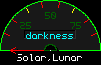 This dial is at zero until the sun reaches the horizon, and will reach
maximum indication (100%) when the sun reaches or exceeds 18° below
the horzion. If the moon is above the horizon, the degree of
illumination (moon phase) will reduce the darkness level.
This dial is at zero until the sun reaches the horizon, and will reach
maximum indication (100%) when the sun reaches or exceeds 18° below
the horzion. If the moon is above the horizon, the degree of
illumination (moon phase) will reduce the darkness level.
If the moon is full and above the horizon, the maximum this meter will
read is 50%. If the moon is 1/2 full, the maximum the meter will read is
75%. The calculation is linear (although the amount of light we get from
the moon relative to its phase is not... because the moon surface
displays more and deeper shadows as the angle to us changes, 1/4 moon is
much, much dimmer than 3/4ths less than the full moon illumination.)
Consequently, if the moon is up, this dial is more advisory than
accurate.
If the moon is not up (or up, but at zero phase), the dial tells you
just what you want to know, as it corresponds directly to the sun's
elevation. In such a case, the two yellow ticks on the dial scale
correspond, left to right, to 6° (civil twilight) and 12°
(nautical twilight), while the right end of the scale is 18°
(astronomical twilight.)
Lunar-Solar separation
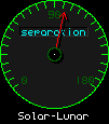 The separation dial gives the angle between the sun and the moon. If
this approches zero, a partial or full solar eclipse (moon obscuring the
sun) may occur for this observing location.
The separation dial gives the angle between the sun and the moon. If
this approches zero, a partial or full solar eclipse (moon obscuring the
sun) may occur for this observing location.
The Weather
Ah, the weather. You would think that current observations of the
weather would be quite accurate. Wouldn't you? Well, you'd be wrong.
First of all, the National Weather Service [NWS] (where I get the data)
only reports the details about once an hour, with occasional
"burps" of data in between. I have the application check every
five minutes so as to catch those burps if and when they happen, but
even so... the accuracy leaves quite a bit to be desired. Please
consider the weather information here advisory only.
Cloud Cover
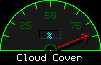 The first thing to be aware of is that the instrument that the NWS uses to
determine cloud coverage only looks at a cone above the NWS station that
covers about 30° of the sky. So they can say no clouds, and you can
go outside, and discover clouds everywhere but over the weather station.
The first thing to be aware of is that the instrument that the NWS uses to
determine cloud coverage only looks at a cone above the NWS station that
covers about 30° of the sky. So they can say no clouds, and you can
go outside, and discover clouds everywhere but over the weather station.
On the other hand, the NWS can indicate it is 100% overcast, and you can
go out, and there will be only one cloud, which is sitting right
on top of the NWS station.
This is the weakest part of the weather information I gather. I include
it simply because if it doesn't indicate clear, you know there were at
least some clouds, somewhere, within the last hour or so.
Absolute and Relative Humidity
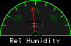 The NWS only reports relative humidity. Relative
humidity is a percentage describing the amount of moisture the
atmosphere can carry at the current temperature and air pressure, both
of which vary. Relative humidity is useful as a weather factor because
it tells you how damp you will "feel" the air is when you're
out in it. But that's not really what we're interested in here.
The NWS only reports relative humidity. Relative
humidity is a percentage describing the amount of moisture the
atmosphere can carry at the current temperature and air pressure, both
of which vary. Relative humidity is useful as a weather factor because
it tells you how damp you will "feel" the air is when you're
out in it. But that's not really what we're interested in here.
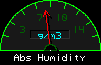 What we really want to know for astronomical viewing purposes is the
actual amount of water suspended in the atmosphere in gaseous
form, regardless of temperature or pressure — because that relates
directly to how much visibility is degraded: Water molecules block,
reflect, and bend light. The more water molecules there are in the
atmosphere between us and the things we're trying to look at, the less
we like it. The amount of water in gas form that is present in the
atmosphere is called "absolute humidity."
What we really want to know for astronomical viewing purposes is the
actual amount of water suspended in the atmosphere in gaseous
form, regardless of temperature or pressure — because that relates
directly to how much visibility is degraded: Water molecules block,
reflect, and bend light. The more water molecules there are in the
atmosphere between us and the things we're trying to look at, the less
we like it. The amount of water in gas form that is present in the
atmosphere is called "absolute humidity."
Through a process that incorporates fixed steam tables, two-dimensional
interpolation, temperature, and pressure, I massage the NWS relative
humidity value into an absolute humidity value that is pretty accurate
between -25°C and 50°C.
Below -25°C (-15°f), the air can't hold much moisture,
and so astronomically speaking, we don't really care. If it gets
over 50°C (which is about 122°f), I don't think you're
going to care very much either, as you'll hopefully be cowering in some
air-conditioned building. I know I will be, anyway.
The displayed value represents grams of water per cubic meter of
atmosphere. The higher the value, the more opaque the atmosphere gets.
Also, when the dew point (the point where the atmosphere can hold no
more moisture at the current temperature) is reached, gaseous moisture
condenses out into droplets, which creates fog. If fog is present,
generally the visibility dial will be below ten miles.
As an interesting tweak, since the maximum amount of water that can
be sustained in gas form varies, I adjust the meter scale to the upper
limit with each measurement. So you'll see the scale labels change
with the temperature. I provide .2, .4, .6 and .8 of scale maximum.
Visibility
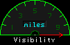 Visibility is reported by the NWS as how far you can see when looking
towards the horizon. It is a scale from 10 miles (very clear) to 0 miles
(fog, snow, other weather that occludes vision.) If it reads ten miles,
you may (probably will) be able to see much further than ten miles. Dust
or humidity may limit you, however, as astronomical observations require
better than ten mile visibility even if you're only looking straight up.
If this dial is not sitting pegged at ten, conditions are probably not
very good. Although, as mentioned previously, the NWS only reports once
an hour, so it may be that the reading is old enough to be wrong. Go
look!
Visibility is reported by the NWS as how far you can see when looking
towards the horizon. It is a scale from 10 miles (very clear) to 0 miles
(fog, snow, other weather that occludes vision.) If it reads ten miles,
you may (probably will) be able to see much further than ten miles. Dust
or humidity may limit you, however, as astronomical observations require
better than ten mile visibility even if you're only looking straight up.
If this dial is not sitting pegged at ten, conditions are probably not
very good. Although, as mentioned previously, the NWS only reports once
an hour, so it may be that the reading is old enough to be wrong. Go
look!
Temperature
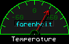 Ah, at last, a weather datum that we can more or less count on. And
which doesn't directly affect seeing much, although it definitely
affects your comfort and should guide you when you prepare to go out,
which is why I monitor it. This is the temperature at the airport NWS
sensor, taken within the last hour.
Ah, at last, a weather datum that we can more or less count on. And
which doesn't directly affect seeing much, although it definitely
affects your comfort and should guide you when you prepare to go out,
which is why I monitor it. This is the temperature at the airport NWS
sensor, taken within the last hour.
K-indices and auroral activity
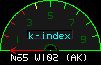
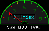
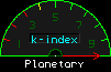 The National Oceanic and Atmospheric Administration [NOAA] monitors all
manner of "space weather" data of considerable interest to the
observer or photgrapher of auroras. They combine the information they
have into a composite number called a "k-index", a value they
(usually) update every three hours for the average conditions during
those three hours (and which, consequently, really is telling you what
did happen, rather than what is happening, or what you can expect
to happen.) If the k-index (I'll come back to that) is four,
there was a possibility of being able to observe faint auroral activity
from a dark location. If the k-indexis five or
higher, the auroras are likely to become quite bright.
The National Oceanic and Atmospheric Administration [NOAA] monitors all
manner of "space weather" data of considerable interest to the
observer or photgrapher of auroras. They combine the information they
have into a composite number called a "k-index", a value they
(usually) update every three hours for the average conditions during
those three hours (and which, consequently, really is telling you what
did happen, rather than what is happening, or what you can expect
to happen.) If the k-index (I'll come back to that) is four,
there was a possibility of being able to observe faint auroral activity
from a dark location. If the k-indexis five or
higher, the auroras are likely to become quite bright.
There are several "gotchas" here. First, you'll note there are
three k-index dials, one for College, Alaska, one for Fredericksburg, Virgina,
and one that is simply marked "Planetary". So what's the value
for the local area, then? Well, uh, you sorta look at the Fredericksburg one...
they're south of us, so we are likely to have a higher value... and then
the planetary one too, as that's orbital... and you... well, you guess.
Secondly, because these are three hour averages... yeah, they're
probably old anyway and don't represent current conditions. Advisory,
again. But higher is definitely better. Still, conditions can change
literally in a minute. Third, for reasons unknown to me, sometimes NOAA
simply fails to report the data, in which case the affected dial(s) will
read zero.
Magnetometer data and auroral activity
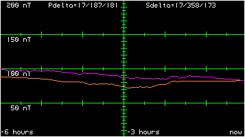 This information is more immediately useful than the K-indices. Six
hours worth of data is available up to the last five minutes (minute,
actually, but I only retrieve it every five minutes) and so you can
actually see what the earth's magnetic field has been doing in the last
six hours.
This information is more immediately useful than the K-indices. Six
hours worth of data is available up to the last five minutes (minute,
actually, but I only retrieve it every five minutes) and so you can
actually see what the earth's magnetic field has been doing in the last
six hours.
If these lines are flat, then there's not much going on in terms of
magnetic field disturbance, and the odds of an aurora are quite low.
If they're jagged and crossing one another, that's good... you might be
able to see something.
There are two lines because there are two satellites, one at west
75° longitude (GOES-16), and the other at west 137° longitude
(GOES-17.) This area is more-or-less at West 106° longitude, so
we're kind of right between them — activity at either one, or
both, can affect our auroral conditions.
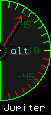
The Planets
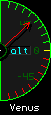
 Each planet (except earth...) gets an azimuth and an elevation dial. The
planets (and all the moons) are daylight objects, photographically
speaking, which means that if you want to shoot them, you use camera
settings similar to those you would when shooting out and about during
the day here on earth. This is because these objects are directly
illuminated by the sun. But because they (with the exception of our own
moon) are so far away, and therefore cover a very small portion of the
sky, they don't contribute enough light to interfere with most deep
space or auroral observations. Consequently, the scales for altitude are
marked with red when they are under the horizon, to remind you
that no, you can't observe them; and green when above, because that
means you can see them.
Each planet (except earth...) gets an azimuth and an elevation dial. The
planets (and all the moons) are daylight objects, photographically
speaking, which means that if you want to shoot them, you use camera
settings similar to those you would when shooting out and about during
the day here on earth. This is because these objects are directly
illuminated by the sun. But because they (with the exception of our own
moon) are so far away, and therefore cover a very small portion of the
sky, they don't contribute enough light to interfere with most deep
space or auroral observations. Consequently, the scales for altitude are
marked with red when they are under the horizon, to remind you
that no, you can't observe them; and green when above, because that
means you can see them.
Perhaps I'll meet someone out there one fine evening!
Why is north down on the azimuth dials?
Because my desk faces south, which puts east and west to my left
and right, respectively. It's very convenient for me this way.
Deal with it. :)
